


Rifle, Colorado


Community Legacy
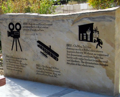
The name ”Rifle Creek” appears in V. F. Hayden’s geological and geographical survey of the Territories in 1876—the same year Colorado gained statehood. A local, and favorite story, of how the town was named has it that a traveler left his rifle leaning against a tree by the creek running through the area and made a map of where to find it at a later date.
With the arrival of the railroad in 1889, Rifle prospered as a booming cattle town necessitating the building of stockyards at the railyard. Stockmen raising sheep in the same area as cattle brought about the Book Cliffs Range War—and led to a grazing act, which permanently divided and defined grazing areas for sheep and cattle.
Today, the Rifle area continues its ranching tradition as well as oil and gas exploration and extraction which began in the early 1900s.
Did you know Rifle was one of the first towns in Colorado to have electric lights powered by a hydroelectric plant at Rifle Falls?
The site of the former power plant—where water cascades down limestone walls—is now a beautiful State Park. Today, children and adults can picnic, camp, and explore the caves of the park. Or, enjoy a hike on the nature trails leading up
to the Rifle Fish Hatchery to see enormous rainbow trout.
Further up the canyon is Rifle Mountain Park, where world class rock climbing extends for 2.5 miles and has over 250 bolted climbing routes for non-winter climbing. Then, when winter arrives and water freezes on the canyons, ice climbers
strap crampons to their boots and ascend the frozen vertical walls. Ice Caves along Koper’s Trail offer a less vertical but no less magical experience. Before the caves were used for recreational pursuits, pioneering ranchers chipped the ice out in blocks and carried them down to lower elevations for cold storage.
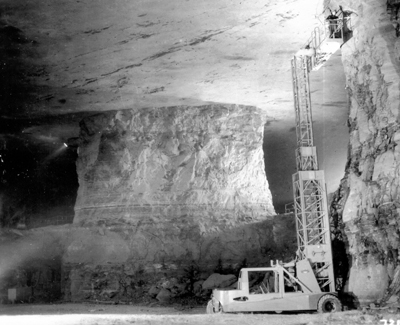
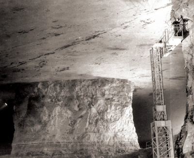
Did you know the Bookcliffs formation contains the richest concentration of oil shale in the world?
Massive layers of oil shale are prominently exposed on the sides of the famed Bookcliffs, seen to the west of Rifle. The oil shale cliffs can be viewed along Interstate 70 for miles to the west into Utah, to Green River, and beyond. There is more kerogen here than there is oil in all of the Middle East. For over 100 years, scientists have been experimenting with ways to extract oil shale “kerogen”—an organic precursor to oil—that must be heated to produce oil and gas.
Deep beneath the oil shale layers of the Piceance Basin, tightly locked in complex geologic formations lies vast quantities of natural gas. Recent advances in well-drilling technology have brought much of the rich gas into production. As a result, Colorado is now among the largest natural gas producers in the nation.
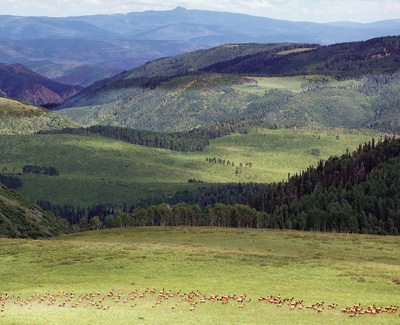
Did you know Rifle is known for its world class hunting?
The White River National Forest and BLM lands surrounding Rifle make the region one of the best world class hunting and fishing destinations in America. Ute Indians were the first to hunt the area—evidence of their wickiups, or shelters, and camps, can still be found along wildlife migration paths. White hunters arrived in the late 1800s, and bow and arrows, black powder and rifles are still used to hunt mountain lions, black bear, elk, and deer.
Theodore Roosevelt set the state record for the largest mountain lion killed in Colorado while on a hunting trip near Rifle, more than 100 years ago. (The record held until 2002.)
Today, the Colorado River, tributary streams, and Rifle Gap Reservoir provide some of the best fishing in the state. You can catch rainbow and German brown trout, walleye, pike, small mouth and large mouth bass, and yellow perch.
Did you know Rifle is consistently cited in state and national top ranked destination lists?
Rifle ranked 28th in Outdoor Life Magazine: Top 200 Towns for Sportsmen, 2011. Rifle Falls State Park placed 6th in Sunset Magazine: Top 10 Waterfalls to Visit, 2011; ranked 66th in the Colorado Tourism Office: Top 99 Gorgeous Places in Colorado, 2012; and Rifle Mountain Park ranked 4th in their Top Rock Climbing Spots in Colorado, 2011.
Directions:
- Only a three-hour drive from Denver and one hour drive from Grand Junction.
- Take Exit 90 off Interstate 70.
CONNECT WITH US: